
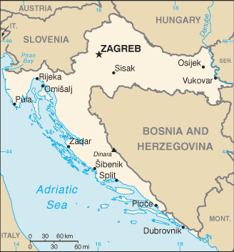
File:Croatia map with updated borders.png
Size of this preview: 328 × 353 pixels.
Original file (328 × 353 pixels, file size: 21 KB, MIME type: image/png)
Summary
Summary
| Description |
CIA Croatia map in Croat |
|---|---|
| Source |
https://www.cia.gov/library/publications/the-world-factbook/geos/hr.html |
| Date | |
| Author |
Central Intelligence Agency |
| Permission (Reusing this file) |
See below.
|
Licensing
| Date/Time | Dimensions | User | Comment |
|---|---|---|---|
| Template:ISOdate | 328 × 353 (16087 bytes) | Krzysiu (talk⧼dot-separator⧽contribs) | CIA Croatia map in Croat *Source: https://www.cia.gov/library/publications/the-world-factbook/geos/hr.html {{PD-USGov-CIA-WF}} [[Category:Maps of Croatia]] |
Preserved source attribution
Authors: Central Intelligence Agency Licence: Public domain () Original uploader: GifTagger.
Import provenance
The recorded source uploader is GifTagger; upload date: 2014-12-03T22:13:54Z. Source description and licensing information, when available, appear above.
File history
Click on a date/time to view the file as it appeared at that time.
| Date/Time | Thumbnail | Dimensions | User | Comment | |
|---|---|---|---|---|---|
| current | 09:05, 31 October 2026 | | 328 × 353 (21 KB) | Maintenance script (talk | contribs) | Imported from recorded source; see file description for attribution |
You cannot overwrite this file.
File usage
The following 2 pages use this file:
